Manage your infrastructure with a complete, collaborative, and intuitive WebGIS
ConnectServices allows you to centralize, visualize, and leverage all your infrastructure data—regardless of your profession or your level of IT/GIS expertise.
ConnectServices, the GIS solution tailored to your business needs
The industry-focused WebGIS ConnectServices gives you simple access to all the GIS tools you need to manage your infrastructure data. ConnectServices is a ready-to-use WebGIS platform designed to store, visualize, analyze, share, and leverage your infrastructure data—whatever the format: FttH, FttX, electricity, gas, IoT, EV charging stations, and more.

Key Features:
- Multi-source, multi-standard data integration
- Collaborative project management
- User management with roles and permissions
- Field intervention planning and tracking
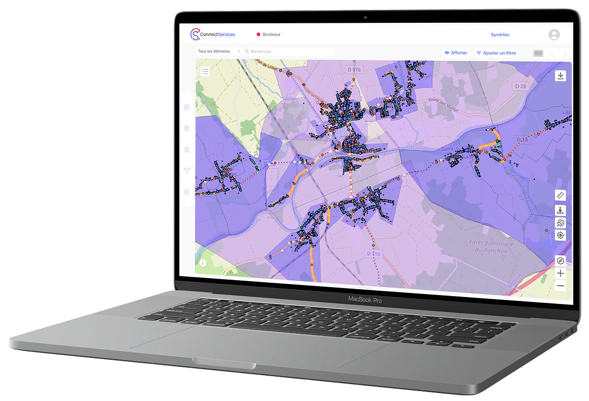
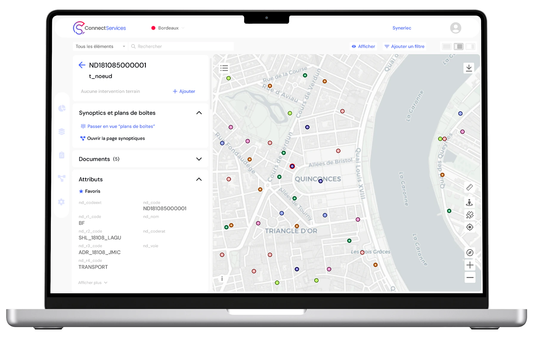
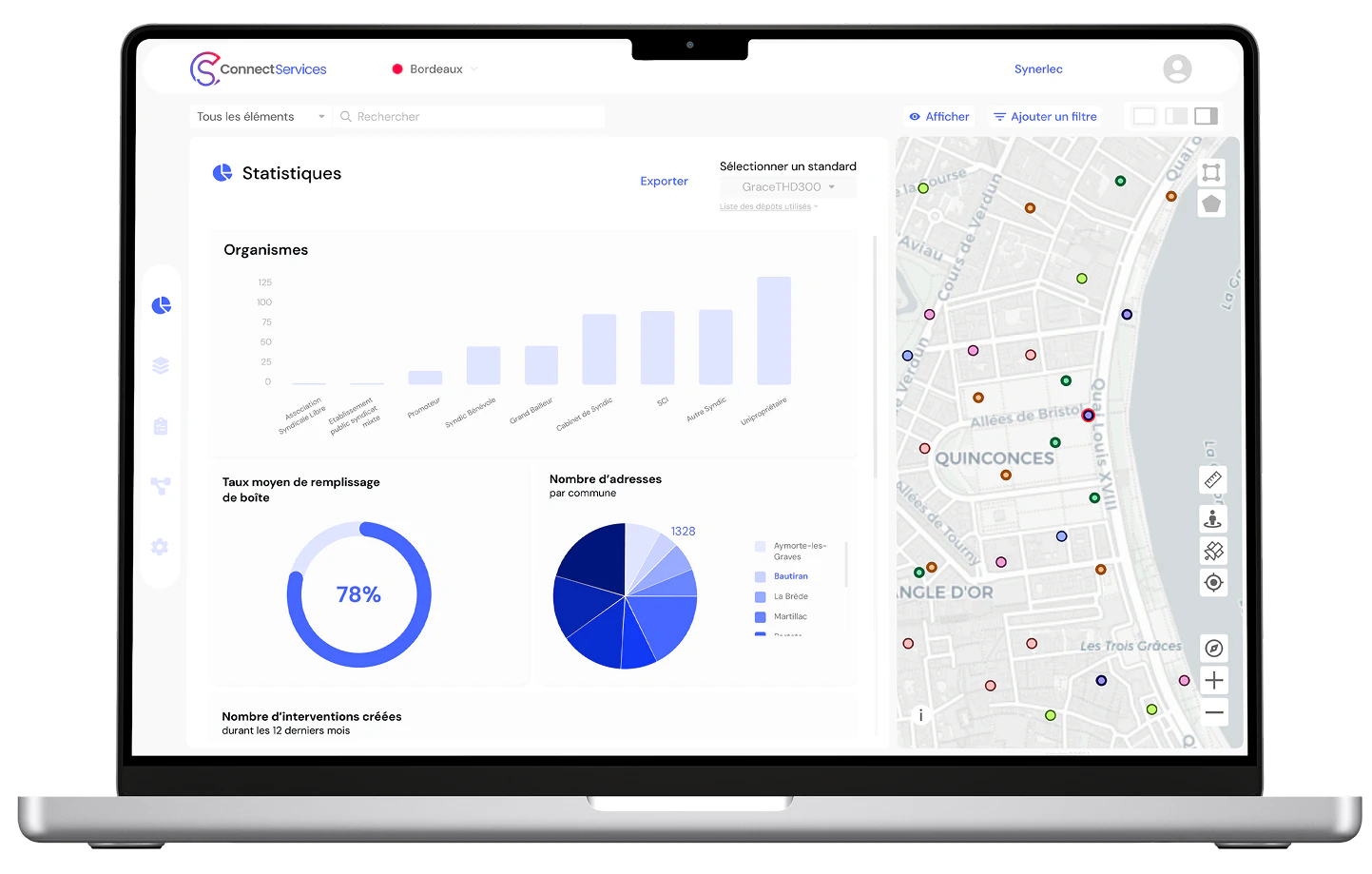
- Interactive map display
- Synoptic (overview) visualization
- Statistical indicators and dashboards
- Data history and version control
- Report generation
Why choose ConnectServices over traditional open source GIS solutions?
ConnectServices stands out for its ease of use, operational flexibility, and field-oriented business logic.
Here’s what makes the difference:
Too heavy, too complex, too slow? If you’ve ever tried general-purpose GIS tools, you know how complicated they can be in everyday use. Open-source solutions are certainly powerful—but they require advanced skills and technical expertise. Configuration takes time, and while the software itself may be free, ongoing use often comes with hidden operational costs.
ConnectServices is built differently: it’s designed to focus on what truly matters to your work—simple and efficient tools for integrating and visualizing your geographic data, pre-configured symbologies based on standards, easy-to-use business data analytics, and seamless field intervention management.
No GIS expertise needed! Data is shared, accessible, and understandable—even for non-experts.
Transparent pricing, no surprises. Our affordable, predictable subscription plans help you optimize operations without impacting your budget.
In addition to the core features expected from any GIS solution, here’s what sets ConnectServices apart from free open-source tools like QGIS:
Access the full power of our WebGIS from just €190/month
Try the platform for freeGeodata control serving the long-term sustainability of your infrastructure
Manage your network assets → Store, visualize, and analyze your data while accessing the key indicators you need for informed decision-making.
Optimize your deployments and maintenance operations → Enhance project tracking through accurate, field-aligned data collection and qualification.
Take control of your infrastructure data → Locate, inventory, audit, and map your assets with a single click—at every stage of the network lifecycle.
Validate the quality of your georeferenced data with on-site control → Drive your audits and monitor equipment directly in the field thanks to seamless integration between ConnectServices and our mobile app, ConnectField.
Ensure infrastructure resilience → Assess external risks and anticipate the actions needed to operate your networks under optimal conditions.
Start now with ConnectServices
Free TrialFrequently Asked Questions (FAQ)
What is a WebGIS?
A WebGIS (Web Geographic Information System), like ConnectServices, is a GIS platform accessible via the internet. It allows users to work with geographic data (maps, layers, attributes, etc.) directly from a web browser—no need to install any specialized software.
What are the benefits of a WebGIS?
The main advantages of a WebGIS platform like ConnectServices include: Accessibility – all you need is an internet connection, Real-time data sharing and synchronization, Enhanced collaboration and multi-user coordination, Cost reduction – no need for heavy licenses or high-end workstations
What is a business-oriented WebGIS?
A business-oriented WebGIS like ConnectServices is an online mapping tool enriched with domain-specific features and data models. It allows non-GIS specialists to interact easily with geographic data relevant to their daily operations.
What are the benefits of a business-oriented WebGIS?
A WebGIS like ConnectServices offers: Fast access to useful information, Autonomy for teams—even those without GIS expertise, The ability to consult, edit, and enrich data, Better coordination between GIS teams and operational staff, Improved data quality through synchronization with mobile apps such as ConnectField for field data collection
What does a business-oriented WebGIS cost?
Prices vary by provider. A solution like ConnectServices currently offers one of the best cost-to-performance ratios, with base pricing starting at €190/month.
What are the core features of a WebGIS?
Key features of a WebGIS such as ConnectServices by Dotic include: Interactive map visualization, Navigation and search tools, Data viewing and querying, Data entry and updates (via mobile apps like ConnectField or other formats such as shapefile or geopackage), Data export and printing, Interoperability and system integration, User and permission management, Mobile accessibility
Does using a WebGIS require technical skills?
Using a WebGIS like ConnectServices doesn’t necessarily require advanced technical skills. It depends on your role. Business users: ConnectServices is designed to be intuitive and user-friendly, even for non-technical users. GIS administrators: Configuring, customizing, or integrating the platform requires more technical expertise.
Are ConnectServices data secure?
es. All data is stored on secure servers located in France. Clients and users remain full owners of their data.
Can ConnectServices data be shared between multiple users?
Yes. ConnectServices is designed to support geographic data sharing. Access to specific data is managed by the organization’s administrator.
Try ConnectServices with your own data!
Stop wasting time with inefficient tools! Discover how ConnectServices and our ConnectField app can transform the way you manage field operations, surveys, audits, and construction or maintenance follow-ups.
Access the solution now!